Friday, March 24, 2017

Milford Track

The Milford Track has been called one of the best walks in the world (or at least in New Zealand) so we had to include it in our trip.  We took a "guided walk" where we only needed to carry our clothes (actually Calvin carried all of our gear) and stayed in very nice lodges and ate gourmet meals.Hiking is not my favorite thing to do, but this was a pretty cushy way to hike.  We started in Queenstown, took a bus to Te Anau and then took a boat to the start of our hike at the north end of Lake Te Anau. 


There were about fifty people in our group, so we all wore name tags to help the guides recognize us.From the boat dock we had a one mile walk to our first night's lodge. 
After we had dropped of our gear we took a nature walk and managed to spot the elusive New Zealand bear.

Our second day involved a little more walking.  We walked ten miles through mostly flat and beautiful terrain.
We crossed a lot of bridges, but didn't have any rain or even need to get our feet wet.

We took a short side trip through a wetlands are where we saw a pretty little red plant called a Sundew that gets protein from insects it traps.
At lunch time we saw one of the few native flightless birds that have managed to survive, a weka, that cleans up the lunch area after we leave.


Day three was the day I was dreading.  It was 4 miles up hill and 5 miles down. We got up early add saw some kea, green parrots that like to eat hiking shoes. The picture isn't really clear but there were hiking shoes nailed to a post at the lodge that the kea like to tear apart.  Apparently they don't really eat the shoes, but I'm sure I saw swallowing going on.
Calvin is loving the hike
but I'm a little less enthusiastic about the uphill.
As we neared the top of the pass we started on a series of switchbacks. Here I am at a switchback hoping that a helicopter will come and pluck me off the mountain.

We did finally make it to the top of the switchbacks and arrived at the McKinnon Memorial.  In honor of the man who was crazy enough to pioneer this route.
While I was trying to catch my breath Calvin took pictures from the top.  If you look closely in this picture you can see the roof of our next hut.

Sadly the MacKinnon Memorial was not the top if the hill.  We still and another twenty minutes up to the top.
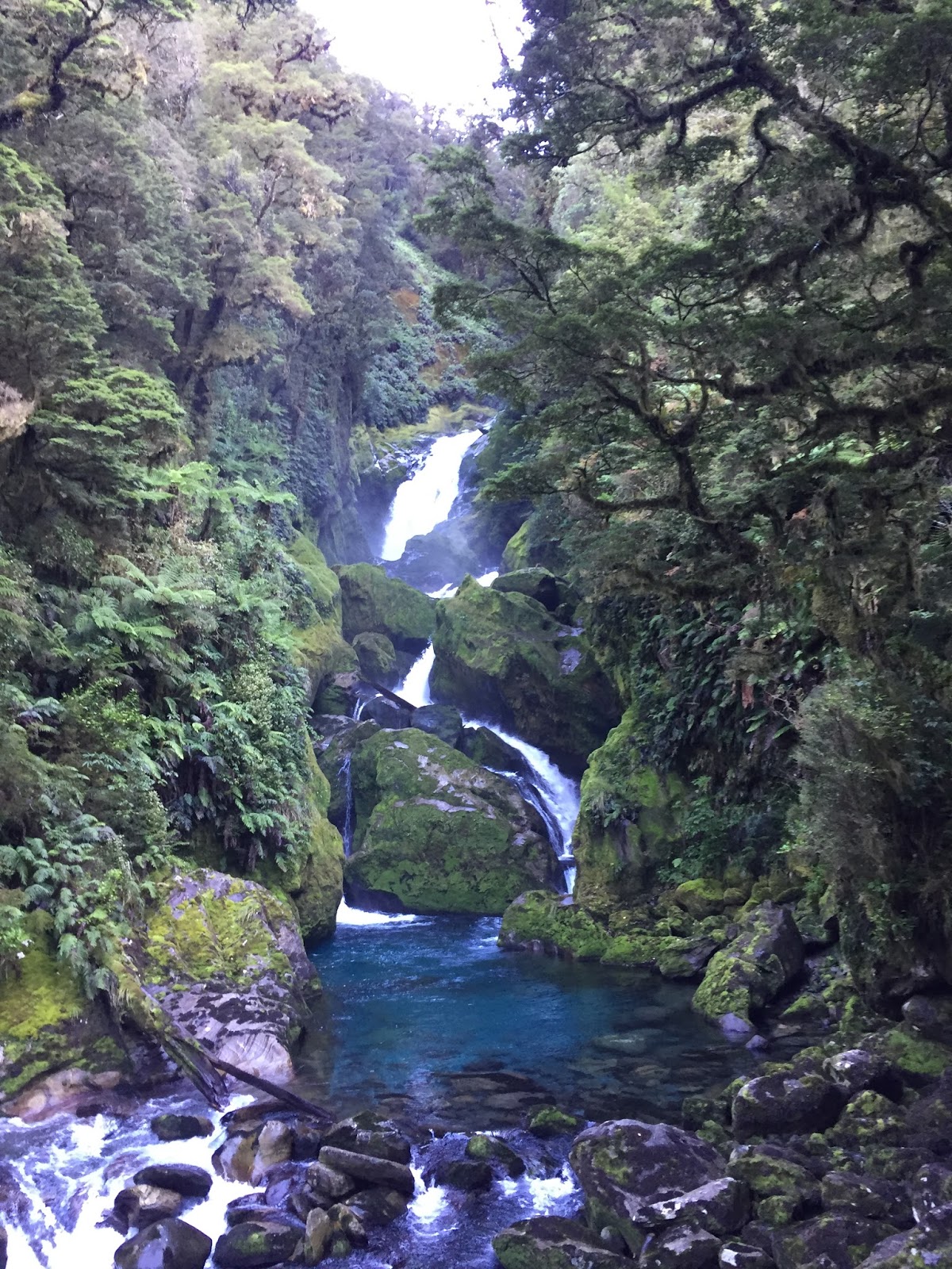
We ate lunch and then started downhill.  I did warn Calvin that I am just as slow going downhill as I am going up hill. It was a long day. We did pass a rather spectacular waterfall
and toward the bottom there were some stairs that made the going a little easier, but that is a day I never plan to repeat.
Day 4 was mostly flat through some beautiful scenery.


We stopped at this waterfall for lunch and I took a foot soak
By the end of the day we had walked thirteen and a half miles to arrive at Sandfly Bay where we took a boat to our last lodge on Milford sound which had a pretty nice view.

Monday, March 13, 2017

Christchurch

We spent a night in Christchurch on our way south.  We just had a few hours to explore, so we decided to take a loop through the downtown.  Our walking map had a large block in the middle of town labeled Re-start. The center of town is still recovering from the 7.1 earthquake in 2010 which was followed shortly by the 6.3 earthquake of 2011. We parked by the Christchurch art gallery, a very modern building that was built in 2003 to survive earthquakes.

The gallery was not open when we walked by, but the outside was pretty interesting.


We walked a block closer to the center of town and got our first view of Christchurch Cathedral, although we didn't know what it was.
The Christchurch Cathedral occupies the very center of the city and it was badly damaged in the earthquakes.
After the 2010 earthquake a steel structure was erected to support the rose window, but during the 2011 quake that steel support took out the entire wall.
The building is unsafe, but litigation is holding up any progress that might be made in either restoration of demolition. So the pigeons have a nice home.
The arch deacon decided that demolition was the answer and it was begun, but the parishioners wanted the church restored.  Structural engineers have determined that the building can be restored and made earthquake safe, but the church does not want to shoulder the entire cost, so for six years it has been in limbo.  Elsewhere massive rebuilding has begun.  Steel frame buildings are going up all around the downtown area,
and cranes dot the skyline.

On the way back to the car I saw this message on the side of the art gallery. "Everything is going to be alright."

Earthquakes in New Zealand are a fact of life.  The 7.3 magnitude 1929 Murchison earthquake caused a landslide that blocked the Maruia River.  The river had to cut a new course and the Maruia Falls are the result.

 Not a bad result for the river, but it was devastating to the people who lived in the region.

Saturday, March 4, 2017

Kayaking Abel Tasman State Park

Luck was on our side and we had three beautiful days of kayaking the shore along the Abel Tasman State Park. We started out from Marahau in a beautiful yellow and purple kayak.


Unlike some of our recent kayak trips, we did this one without a guide.  Abel Tasman kayaks rented us the equipment, booked lodging in the park, arranged for a water taxi pick-up at the end of the trip and gave us a map.  After a quick water test to see if we could kayak he took our picture and we paddled off on our own. Sweet.

We paddled for about three hours with a generous lunch break on the beach and arrived at our first night's lodging at Anchorage Bay.  We stayed in the Anchorage Bay hut in bunk beds with about 34 of our soon to be closest friends, 8 beds to a room.  It was a mixed group of trail hikers and kayakers. It was pretty quiet in the room, with the only sounds to be heard in the night were Calvin and I coughing as we are both on the tail end of a nasty cold.  Most of the hikers got up early to start on the trail, but Calvin and I got a leisurely start at 10. We were waiting for the tide to come in so we didn't have to drag our kayak so far to the water.


We paddled along the shore for a little while and then took a break at Frenchman's Bay where we shared the beach with a friendly seagull.


There was a cool tidal lagoon just beyond the beach that we paddled into as the tide was coming in, then headed across the channel to Pinacle Island where we saw several fur seals sunning in the rocks.
That didn't take very long, so we poked our nose into Falls River, a tidal river at almost high tide.


We paddled to a rock fall in the river under a swinging bridge.

By this time it was time to pull into Bark Bay to check out our accommodations for the night.
Seven sleeping pads on the bottom and seven sleeping pads on the top.  Luckily we arrived in time to get the bottom row.
After claiming our sleeping pad there wasn't much else to do so we set out on foot to explore.  Here is the swinging bridge that we saw from Falls River.  I thought it was a little scary but Calvin thought it was fun.


Then we hiked up to South point for a great view of the coastline we had paddled in the morning.

and a view of Pinacle Island where the seals hang out

After a restful night with our new best friends, who weren't too happy with us because we were still coughing, we started our last short paddle. This is what Caslvin sees when he is paddling.

This is what I see
Calvin si a good sport.
This is what I would see if I had eyes in the back of my head.
The beach behind Calvin is where we waited for the water taxi. An easy place to spend a couple of hours.